A trip to this western edge of our island is not only an immersive tour experience, but also an exploratory walk through the history of many centuries: the area of Polis Chrysochous is believed to have been inhabited since the Cypro-Archaic Period (725-475 B.C.) and was one of the ten ancient kingdoms of Cyprus. However, from evidence found to date from inscriptions and coins, we only know the names of a few of the kings of Marion from the 5th and 4th centuries B.C.

The area of Chrysochou Bay is rich both geographically and historically. It is also adorned with natural beauty: the endless blue of the Mediterranean Sea, long pebble beaches, picturesque sunny valleys and historical and cultural treasures, as well as legends and ancient myths artfully intertwined with the present day, in a place where ancient gods and kings used to live and were worshipped. It is ultimately a wonderful attraction for nature enthusiasts, explorers, and the admirers of its history, culture, and Cyprus’ unique local identity. Demanding travelers and swimmers who visit the area marvel at the majestic exotic beaches, the warm Mediterranean climate, the crystal clear blue waters, the unique landscapes, the gastronomic local delights, and moments of peace and relaxation, away from the crowds of the cosmopolitan resorts. A trip to Polis Chrysochous is also an opportunity to get acquainted with the neighboring Akamas peninsula to the west and the wider area of Chrysochou Bay and its picturesque villages to the east. All these, combined with the genuine and cordial hospitality of the locals, comprise the perfect panorama for an unforgettable escape to both the residential areas and the seaside landscapes of the region.

Polis Chrysochous invites you to discover it by following one of the two scenic routes from the town of Pafos, either through the lush green Stroumpi (B7), or by choosing the coastal route through Pegeia (E709), overlooking the endless blue of the Mediterranean Sea and the smooth elevations of the imposing Laona plateau.

Latsi, with its attractive beaches and an ever-increasing development of tourist accommodation and restaurants, attracts thousands of visitors every year. They seek relaxation, nice clean waters for swimming, and beautiful landscapes for exploring. Organized cruises are also offered from Latsi, to explore the eastern coastline of Akamas towards the famous Baths of Aphrodite and the idyllic Fontana Amorosa, until reaching the cape of Akamas.

The sea surrounding the area, apart from its attractive beaches, is considered a hot spot for its marine biodiversity on a global scale, and an important and fertile habitat or refuge for many living organisms. Some marine species that are also found in other parts of the island, such as the Loggerhead turtle (Caretta caretta and the Mediterranean monk seal, which are classed as vulnerable, are found in the marine environment to the west and east of Polis Chrysochous The ‘Posidonia oceanica’ seagrass, which is endemic to the Mediterranean and considered to be its most important marine ecosystem, holds an honorary place in this western edge of Cyprus, since one of the deepest Posidonia meadows in the Mediterranean has been found in the Akamas region. The turtles that nest on the beaches of Polis Chrysochous usually find protection in the underwater meadow, while they feed and breed.

The town was built on the foundations of ancient Marion, one of the ten ancient city kingdoms of Cyprus. Indeed, Marion was one of the most important ancient kingdoms of Cyprus, is associated with the valley of today’s Polis Chrysochous.

Ancient Marion was one of the richest kingdoms of Cyprus, due to its geographical position and the rich copper deposits in the neighboring Limni Mine as well as the presence of a port, from which goods could be exported and imported. Its geographical location also allowed it to establish relations with mainland Greece, since it was the closest port to Greece, and this is where ships from the west used to arrive first.

From the Guide to “Exploring Polis Chrysochous, A journey through the villages of Chrysochou Bay and Akamas”.

The book is available at the Museum of Sea and Culture of Polis-Latsi

SELAS participated in the publication and documentation of the work, contributing to the cultural and geographical recording of the region.

Cyprus is the third island in the Mediterranean, comprising an area of 9,251sq km. The island is characterized by considerable diversity of scenery, ranging from flat plains, a few metres above sea level, to lofty mountainous areas reaching a height of 1951 metres. A large number of geomorphological features, like raised beaches, tombolos, sea cliffs and sea caves, cuestas, ravines and gorges, river captures, coastal sand dunes, beautiful tiny isles and, above all, fine and coarse-grained sandy beaches are encountered. A great variety of rocks, belonging to different geological eras and ranging from sedimentary to metamorphic and igneous, with their hardness, colour and texture affect the relief, lending a distinct colour to the landscape of Cyprus.

The natural vegetation, influenced by the island’s position among three continents, is rich and varied with a number of endemic plants. Equally significant is the fauna of the island, with its unique moufflons roaming in herds in the forests of Pafos and Troodos. Moreover, millions of migratory birds use Cyprus as a stopover in their movement from the cold north-European countries to the warm countries of the African continent, and vice versa, during autumn, winter and spring.

What, however, makes Cyprus a very attractive and fascinating country for the foreign visitor, is its long and tempestuous history, dating back to the Neolithic times. Recent excavations at Shillourokambos, north of Amathous in Limassol district, place the neolithic era in Cyprus at 8200 B.C. Besides, all conquerors and settlers have left their imprints on the surface of the island. Every span of land in Cyprus has something to reveal to the visitor, local or foreign. It has often been written, that nowhere else in the world will the visitor find a similar size of land with such a large variety of physical and man-made environment. It is this tremendous variety of landscape that satisfies all needs and tastes. The visitors can visit archaeological sites and museums, popular neighborhoods and folk-art museums, basilicas and Byzantine frescoed churches, traditional houses and wine-presses. They can walk over cobbled streets and medieval bridges, or they can admire the large wine jars of the last two centuries, currently placed in the house yards for decorative purposes. They can take part in local festivals and dance contests, or they can watch or participate in the citrus, olive and grape gathering. Yet, if they like isolation, trekking, or countryside exploration, there are unspoiled areas, nature trails, large expanses of forest land and small, declining villages preserving their genuine customs and habits, particularly their hospitality. It is not surprising that the fruitful Greek imagination, wise and infallible in all its creative conceptions, chose out of all islands, Cyprus, as the birthplace of the Goddess of Love and Beauty, a symbolical realization of the island’s natural beauties and its poetic, romantic environment.

This guide, published by SELAS, aims at presenting to the visitors of Cyprus the physical and cultural heritage of the island.

Extract from the Touring Guide of Cyprus published by SELAS PUBLICATIONS

Cyprus is one of the biodiversity hotspots of the Eastern Mediterranean. Situated at the crossroads of Europe, Asia and Africa, the island supports an exceptional variety of plants, mammals, birds and marine life. Its diverse habitats, from mountain forests to coastal wetlands, are home to many endemic species found nowhere else.

Forests of Cyprus

Forests cover approximately 17% of Cyprus and are concentrated mainly in the Troodos and Pafos mountain ranges.

The dominant tree species include the Cyprus pine (Pinus brutia), the Black pine (Pinus nigra), the Cyprus cedar (Cedrus brevifolia), the Golden oak (Quercus alnifolia), the Strawberry tree (Arbutus unedo), etc.

Mountain valleys also support plane trees, alder and maple, while coastal regions such as the Akamas Peninsula are characterised by juniper species.

Mediterranean Shrublands

Outside the forests, Cyprus is covered by two characteristic Mediterranean vegetation types:

Maquis

Dense evergreen shrubland including myrtle, rosemary, oleander and strawberry tree.

Garrigue

Open limestone scrub dominated by thyme, lentisk, capers and other aromatic drought-resistant plants. These habitats support many pollinators and reptiles.

Wildlife of Cyprus

Cyprus hosts a rich variety of wildlife despite its relatively small size.

The Cyprus mouflon is the island’s only large wild mammal and is one of Cyprus’ most recognizable conservation success stories.

Cyprus also lies on one of the world’s major migration routes for birds between Europe and Africa. Every spring and autumn, hundreds of bird species pass through the island, particularly around the Larnaka, Akrotiri salt lakes as well as in the Akamas peninsula. These wetlands are internationally important habitats.

Marine Life is also important. Cyprus’ coastal waters support fish species, crabs, sea sponges and echinoderms such as sea stars and sea urchins.

The Mediterranean monk seal and nesting sea turtles are also among the island’s protected marine species.

Why Cyprus is a biodiversity hotspot

The combination of Mediterranean climate, the varied geology and the strategic geographical location has created exceptional ecological diversity.More than 1,900 plant species occur in Cyprus, including many endemic plants found nowhere else in the world.

SELAS has produced numerous environmental studies and publications covering biodiversity, habitats, protected areas and environmental management across Cyprus.

Learn more about Cyprus’fauna and flora in our publication Touring Guide of Cyprus

Ancient writers, present-day historians, philologists, linguists and other researchers have been arguing concerning the origin of the name of KYPROS (Cyprus). The most dominant interpretations are the following ones:

(a) From a plan, called kypros (henna). For a long time, it was believed that Cyprus obtained its name from a shrub called kypros of henna (Lawsonia alba) Though this plant is native to North Africa, Arabia, Persia and India, it was never plethoric in Cyprus and even today scarcely this shrub can be found. It is unlikely that a relatively large island with a long history and a civilization dating back to a few millenia got its name from a non-native shrub.

(b) From a town of Cyprus name Kypros. According to Onorios and Isodoros, the name is due to a town lying between Kyrenia and Akanthou in the northern part of Cyprus. However, such a town has never been unearthed not has historically been ascertained that there was an important town by this name. 

(c) From Kypris. A number of ancient writers use the adjective “Kypris” for Aphrodite, while Homer calls Aphrodite Kypris. Though a few writers underline that Kypros (Cyprus) owns its name to Kypris, nevertheless it is Kypris that has derived its name from Kypros, since Kypris was the Goddess of Kypros (Cyprus).

(d) From Kypros the son or daughter of Kinyras.

(e) From copper. The Bronze period in Cyprus starts from 2500 B.C. and continues until 1050 B.C. During this period the production and exploitation of copper brought about a true revolution in everyday life and economy of Cyprus. Cyprus, on account of copper, became well known in the then known world. The strategic position of Cyprus and the production of copper made Cyprus a pole of attraction for the different countries of the world.  Among those who were lured by the copper trade of Cyprus, were the Myceneans (Achaians), who settled in Cyprus in the 14th century B.C. and thereafter Hellenised the island. The name Kypros appeared not as late as the Homeric time (8th century B.C.). There is also another interpretation that copper took its name from Kypros (Cyprus).

Extract from the Touring Guide of Cyprus published by SELAS PUBLICATIONS

Cyprus is one of the most geologically fascinating islands in the Mediterranean. Its mountains, plains and coastline have been shaped over millions of years by powerful tectonic movements, creating a landscape unlike any other in Europe. Understanding the physical geography of Cyprus helps explain its unique biodiversity, climate, natural resources and history.

Geological History of Cyprus

It is currently believed that the most conspicuous geological feature of Cyprus is the collision of the Euro-Asian and African tectonic plates with took place about 80 million years ago. About 25 million years ago, during the Lower Miocene era, the igneous complex of Troodos constituted an isle, while the Mesaoria plain, to the north, and the Pentadaktylos or Kerynia range, further north, were under the sea. By the end of the Miocene era, about 11 million years ago, the Pentadaktylos started elevating above the sea, while the Mesaoria plain remained under the sea, to appear much later during the Pleistocene era, about one million years ago. All other details of the geological history of Cyprus, particularly those concerning the coastline, were formed later. It is this tempestuous geological history which is responsible for a great variety of rocks: igneous, metamorphic and sedimentary, hard and soft, fractured and unaltered, of different colour and texture, now at a small distance from each other on the island’s surface.

The Five Main Physical Regions of Cyprus

The present topography of Cyprus can be sub-divided into five morphological regions:

  1. Kyrenia (Pentadaktylos) Mountain Range. This is the northern mountain chain of Cyprus, appearing as a narrow arc-like strip of land. The highest summit, Kyparissovouno, reaches a height of 1024 meters and is made up of relatively hard limestones.
  2. Troodos Mountains. The central-western part of Cyprus is occupied by the igneous massif of Troodos.  The resistant igneous rocks of this mountain block (dunnites, serpentinite, gabbros, diabase, etc.). If you are planning to explore the area on foot, read our Troodos Mountains Hiking Guide.
  3. Hills Surrounding Troodos mountain and south of the Kerynia range. They extend mainly east, south and west of the ophiolite complex of Troodos and consist mainly of chalks. They give rise to a rounded, bare, white landscape, under dry-fed cultivations, particularly vineyards.
  4. Mesaoria plain. The central plain of Cyprus, often known as Mesaoria, lies between the two mountains and has a very low altitude which does not exceed 180 meters a.s.l. close to Nicosia. It consists of sediments which have been transported and deposited by steams in recent geological times from the Troodos and the Kerynia ranges.Explore Cyprus with our Cyprus Road Map Guide
  5. Coastal Plains. Almost around Cyprus appear narrow coastal plains which in fact are raised beaches. In the north is the coastal plain of Kerynia which is very narrow but with scenic laced beaches. To the south is the plain of Larnaka lying below 100 meters a.s.l. and composed of alluvium and terrace deposits of recent geological formation. The most important geomorphological feature is the Salt Lake separated from the sea by porous deposits. The coastal plain of Limassol, lying below 200m, occupies mainly the Akrotiri peninsula with extensions to Pissouri-Avdimou to the west and small areas east of Amathous. The most conspicuous geomorphological feature of the region is the Akrotiri Lake. The coastal plain of Chrysochou extends east and west of Polis and includes part of the narrow Chrysochou valley to the south.Nature lovers may also enjoy our Touring guide of Pafos with special chapters on the Akamas Peninsula

Interested in learning more about the geography of Cyprus?

Explore SELAS Publications and discover our detailed maps of Cyprus, trusted by schools, professionals and geography enthusiasts for decades.

Discover more about Cyprus through our blog posts:

Related Articles

Troodos Mountains Hiking Guide: trails, nature & maps

Cyprus Hiking Maps: Topographical Maps for Trails & Mountain Biking

Cyprus Road Map Guide: Exploring the island with confidence

The Solea Valley: villages, nature and excursions in the Troodos area

Flora and Fauna of Cyprus: Discover the island’s unique biodiversity

Akamas Peninsula – Natural, Historical & Hiking Guide

Frequently Asked Questions

What are the five main physical regions of Cyprus?

Cyprus consists of the Kyrenia (Pentadaktylos) Mountain Range, the Troodos Mountains, the hills surrounding Troodos, the Mesaoria Plain and the Coastal Plains.

Why are the Troodos Mountains important?

The Troodos Mountains are one of the world’s best-preserved ophiolite complexes and provide valuable insight into the formation of the Earth’s oceanic crust.

What is the Mesaoria Plain?

The Mesaoria Plain is the large central plain of Cyprus located between the Troodos and Kyrenia mountain ranges. It is one of the island’s main agricultural regions.

Few journeys in Cyprus combine spectacular landscapes, traditional villages, fascinating geology and centuries of history as beautifully as the drive through Ineia and the Laona Plateau. Overlooking the rugged coastline of the Akamas Peninsula, this scenic route offers visitors an authentic experience of rural Cyprus, where vineyards, ancient pathways, dramatic rock formations and timeless traditions coexist.

Whether you are interested in nature, photography, geology, birdwatching or simply discovering one of Cyprus’ most picturesque regions, the Laona Plateau is a destination worth exploring.

Where is the Laona Plateau?

The Laona Plateau occupies the northwestern part of the Pafos District and consists of a group of traditional villages, including Kathikas, Pano Arodes, Kato Arodes, Ineia, Drouseia, Kritou Tera, Androlykou and Fasli.

Its location creates one of the island’s most impressive landscapes. To the northwest lies the protected Akamas Peninsula, while the Chrysochous coastal plain stretches to the north. To the east, fertile valleys descend towards Polis Chrysochous, and to the southwest the landscape gradually opens towards the coastal plain of Pafos.

Following an ancient ridge road

The road linking Kathikas, Arodes, Ineia and Drouseia follows an elevated ridge that has served as a communication route for centuries.

Historical evidence suggests that parts of this route were already in use during Roman times. Archaeological and historical studies, including those documented by Jane Fejfer in Ancient Akamas, identify this ridge road as one of the principal routes connecting settlements across the Akamas region.

Today, the winding asphalt road allows visitors to enjoy panoramic views in every direction while travelling through one of the island’s most beautiful rural landscapes.

A landscape shaped by agriculture

Driving across the plateau reveals a landscape that has been cultivated for generations.

Vineyards cover many of the gentle slopes, while almond trees, olive groves, carob trees and seasonal crops form a colorful mosaic throughout the year. Between cultivated fields, natural mediterranean vegetation survives almost untouched.

Large terebinth trees, many of them centuries old, continue to provide shelter for numerous bird species, including both resident and migratory birds that use the Akamas Peninsula as an important migration corridor.

Cyprus traditional villages with timeless character

Despite gradual development and the growth of agrotourism, the villages of Laona have managed to preserve much of their traditional character.

Stone-built houses, arched doorways, timber roofs and enclosed courtyards still reflect the area’s architectural heritage. Seasonal customs continue to form part of village life, including the grape harvest, the preparation of traditional sweets such as palouze and soutzoukos, Easter celebrations and the pastoral traditions that have shaped the region for centuries.

Sheep and goats are still commonly seen grazing on the surrounding hillsides, reinforcing the authentic rural atmosphere that distinguishes Laona from many other parts of Cyprus.

A Geological treasure

The Laona plateau is equally remarkable from a geological perspective. Its landscape has been sculpted by erosion over millions of years, producing an intricate network of valleys, hills, steep slopes and seasonal streams.

The geology is exceptionally diverse and includes limestone, sandstone, chalk, marl, serpentinite, volcanic rocks and formations belonging to the Mamonia Complex. This extraordinary geodiversity makes the region one of the most interesting natural laboratories in Cyprus.

Vouni of Ineia – The highest point of Laona plateau

Although many locations across the plateau enjoy wide panoramic views, the finest viewpoint is undoubtedly Vouni of Ineia, also known as Vouni of Agios Georgios.

Rising to approximately 668 metres above sea level, it is the highest point on the Laona plateau. At its summit stands the small chapel of Agios Georgios, offering uninterrupted views across the peninsula, the surrounding villages, Chrysochous Bay and the western coastline of Cyprus.

The hill itself is formed by deep marine sediments, including radiolarites and quartz-rich sandstones, providing valuable evidence of the island’s complex geological history.

The spectacular quartz sandstone cliffs

The eponymous geomorphologies of Ineia are particularly imposing in the landscape and are surrounded by wild vegetation as well as rich bird and reptile fauna. These rocks, as well as the rest of the rocks of the Vouni hill, are quartz sandstones and have the same composition and age, that is, between 210-95 million years.

These towering cliffs provide nesting sites for a variety of bird species and create one of the most dramatic landscapes in western Cyprus. Historically, the cliffs were home to colonies of vultures, which unfortunately have almost disappeared from the region. Today the area supports a variety of other birds, including jackdaws, rock doves, kestrels, peregrine falcons and barn owls.

These formations are a major destination for professional and amateur rock climbers.

A landscape rich in History

The strategic position of Ineia has attracted attention for centuries.

In his 1918 publication A Description of the Historic Monuments of Cyprus, George Jeffery suggested that the hill above the village may once have hosted a sixteenth-century observation point because of its commanding views over the coastline.

Historical cartography provides further evidence of the settlement’s importance. Maps published by Abraham Ortelius in 1573 and Vincenzo Maria Coronelli in 1689 identify the settlement as Igna -today’s Ineia- and include references to an observation point overlooking the surrounding coast. These early maps also record a settlement named Ara, which is generally associated with the present-day Lara area.

Why visit Ineia?

A journey through Ineia and the Laona plateau is far more than a scenic drive.

Visitors can combine spectacular viewpoints with traditional villages, geological landmarks, historic routes, birdwatching opportunities and authentic cypriot hospitality. The region offers an excellent introduction to the natural and cultural heritage of the Akamas peninsula while remaining one of western Cyprus’ most rewarding destinations.

Whether you spend a few hours exploring the villages or devote an entire day to discovering the plateau, the journey reveals a side of Cyprus where landscape, history and tradition continue to exist in remarkable harmony.

This article is based on the guide Exploring Ineia and the Beaches of Lara.

The guide is available at the Ineia–Lara Turtle Museum and Educational Centre.

SELAS contributed to the publication by providing geographical, historical and cartographic documentation, producing maps, and developing the official website for Ineia village. The company also provided services for the creation of the Inνia–Lara Turtle Museum and Educational Centre, supporting the preservation and promotion of the area’s rich cultural and geographical heritage. Learn more about the project on the SELAS website.

Learn more about the Ineia-Lara Turtle Museum project.

Visit the official Ineia-Akamas website for more information about Ineia and the beaches of Lara.

A visit to Stavros tis Psokas is recommended for those who like to get acquainted with the mountainous forested landscape of Cyprus and particularly those who like to see on the spot moufflon’s, a unique endemic species of the sheep family. The visitor can approach Stavros tis Psokas through the village of Lysos. Though the distance on the map appears to be short, nevertheless, the time required is rather long, since the traveler must follow earthen, meandering, often narrow roads. The road is, however, hard and resistant, as it lies on igneous rocks. The dominant forest tree throughout the route is the pine and the golden oak. Wild olive trees appear in some areas while the plane trees grow in deep valleys. On the way to Stavros tis Psokas the traveler might be lucky to meet groups of moufflon. 

Stavros tis Psokas is a forest settlement, with filed, steep pitched houses made of wood, including guest houses for those who would like to spend a few nights in the Station. 

The environment at Stavros, amid the lush vegetation of pines, chestnut and cypress trees, next to cedar, golden oak and maple is very pleasant, quiet and cool, particularly in the worm summer days. In an enclosure the visitor can see the moufflon, the national animal of Cyprus. A few deer, kept for acclimatization in enclosures, can also been seen. They are beautiful, fast running animals with the males having deciduous antlers. The deers, as historically know, used to live in Cyprus up to the Middle Ages. They were abundant in almost all the forests of Cyprus. A few trails have been set up for those who would like to combine the visit with walking amid a cool, refreshing, forested landscape.

Moufflon

Moufflon is an old as the first inhabitants of Cyprus or the first Neolithic settlements of the island. In Neolithic times it was hunted and caught for its meat as well as for its bones. Later on, particularly in the Hellenistic-Roman time, its presence is evidenced by the mosaics of Pafos. In the Middle Ages it was the game of the noble Frankish ruling class.

In 1939, the Forest of Pafos, where the animals live, was declared a reserve area. The moufflon has been used on stamps, coins, posters, etc. Though in the past moufflons could be encountered in the Troodos Forest, currently they are confined to the Forest of Pafos. There is a seasonal movement to higher areas of the forest in summer and to the lower in winter. Its pale brown hair protects it from the enemy, as it resembles the colour of the natural vegetation. The moufflon belongs to the sheep family with the male having horns like those of a ram, and the female bearing no horns. The animals live from 15 to 20 years and are very elegant, powerful and handsome. As soon as they feel the presence of the man they disappear. Normally they appear in groups of five or six

Extract from the Touring Guide of Pafos published by SELAS PUBLICATIONS LTD

Avakas gorge, is about 2km long originating at Koloni, west of Arodes settlement and ending up in Toxeftra. The gorge is the combined product of valley deepening, the rising of the land in relation to the sea and the subsequent rejuvenation of the river system by deepening vertically the pre-existing river valley.

If a visitor wishes to explore the two km gorge, walking is recommended from Koloni (Arodes). If, however, one wishes to see the mouth of the gorge only, then the visit can be accomplished from Toxeftra in Pegia, near the sea. Exploring the gorge from Arodes, one can walk along the deep, steep sided valley with cliffs on both sides, at points reaching the height of almost a hundred meters. Huge rocks, which feel from the sides, blocked the valley, while elsewhere the water of the stream disappears to reappear further west. 

You encounter arches and caves, while some hollows on the stream bed fill with water even in summer. There is a rich variety of flora, such as poplar, cypress, wild carob and olive trees, lentisk trees, gorge, terebinth, thyme, rockrose, bramble and oleander. The fauna consists of foxes, wild pigeons, partridges, a few hares and other migratory or endemic birds. A few night birds and some serpents are also present. In the past vultures lived on the steep limestone cliffs, but have now abandoned the place. 

Suitable boots are required as well as a camera. The exploration of the gorge is not recommended in winter months when the river is impassable. The mystery that accompany the passage of the gorge make the exploration very challenging.

Extract from the Touring Guide of Pafos published by SELAS PUBLICATIONS LTD

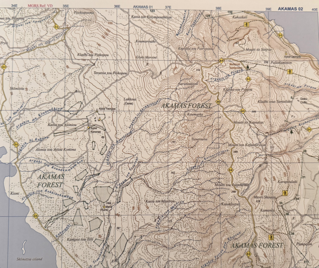
Akamas, situated in the extreme north-west part of Pafos, is one of the most pristine and ecologically important regions in Cyprus. It combines wild natural landscapes, rich biodiversity, and deep historical heritage, making it a unique destination for hiking and exploration.

For a complete overview of hiking routes and maps across Cyprus, visit the official guide:
Cyprus Hiking Maps – Complete Guide
https://www.selas.com.cy/cyprus-hiking-maps/

Natural Environment of Akamas

The Akamas Peninsula is famous for its unspoiled coastline, rugged terrain, and rare plant species. Many areas remain untouched, preserving their natural ecosystem and endemic flora.

Beyond its natural value, Akamas is also a cultural landscape shaped by thousands of years of human presence, from the Chalcolithic period through the Byzantine era.

Historical Significance

Akamas has been inhabited since prehistoric times and later developed during the Hellenistic, Roman, and Byzantine periods. Archaeological evidence shows small settlements, religious sites, and rural communities scattered across the peninsula.

Many of these settlements were later abandoned due to historical invasions and population movements, leaving behind chapels, ruins, and cultural landmarks.

Geology of Akamas

The geology of Akamas is highly complex and diverse, making it one of the most interesting geological regions in Cyprus.

It includes:

  • formations from the ophiolite complex of Troodos Mountains
  • sedimentary rock layers
  • and formations from the Mamonia complex

The peninsula features serpentinite belts, gabbros, basaltic lava flows, limestone formations, and marine terraces shaped by erosion over millions of years.

Mineral Resources

Historically, Akamas had limited but notable mineral activity.

  • Magnesite was mined and exported decades ago
  • Copper and iron deposits exist but were never extensively exploited
  • Limestone and bentonite formations occur in limited areas

Abandoned mining sites and shafts can still be found in parts of the region.

Landscape and Scenery

The landscape of Akamas is shaped by tectonic activity and erosion. A central ridge divides the peninsula, creating deep valleys, gorges, and coastal terraces.

Elevations reach nearly 500 meters, offering panoramic views of both inland forests and coastal areas.

This geological diversity makes Akamas a visually striking and highly varied hiking environment.

Hiking in Akamas Today

Today, Akamas is one of the most popular hiking and mountain biking destinations in Cyprus. The area includes coastal trails, forest paths, and sections of the European E4 long-distance trail.

Due to its remote terrain and limited signage, proper navigation tools are essential.

Why Hiking Maps Are Essential

Exploring Akamas safely requires accurate topographical maps because:

  • mobile signal is often unavailable
  • trails are not always clearly marked
  • terrain can be steep and remote

Topographical maps provide:

  • elevation and contour detail
  • accurate trail routes
  • offline reliability
  • safer route planning

For full navigation across all hiking regions of Cyprus, see:

Cyprus Hiking Maps – Official Guide

https://www.selas.com.cy/products/topographical-maps

Touring Guide of Pafos – Recommended Publication

To fully understand the cultural and historical context of Akamas and the wider Pafos region, the following publication is highly recommended:

The Touring Guide of Pafos – Town & Countryside (SELAS Publications)
https://www.selas.com.cy/product/travel-guide-of-pafos-town-countryside-in-english/

This guide includes:

  • historical and archaeological sites
  • traditional villages
  • countryside exploration routes
  • and detailed regional insights covering Pafos and Akamas

It is an essential companion for travelers who want to go beyond hiking and explore the cultural depth of the region.

Akamas remains one of the most untouched and valuable natural regions in Cyprus. Its combination of geology, biodiversity, and history makes it a top destination for hikers, nature lovers, and explorers.

With the right maps and guides, visitors can experience the region safely and meaningfully, discovering both its natural beauty and cultural heritage.

Text is extract from the Touring Guide of Pafos published by SELAS PUBLICATIONS LTD

© 2026 SELAS PUBLICATIONS LTD. All Rights Reserved. Website Designed & Developed by Ruxbo