Education
Cyprus’s leading provider of geography-based educational products for teachers and students

Atlas mapping has always been at the heart of SELAS’s expertise.
Our team of experienced geographers and cartographers combines scientific knowledge, cartographic expertise and contemporary design to produce geographical atlases that are both educationally effective and visually engaging.
SELAS geographical atlases have received Gold and Silver Awards in international cartographic competitions, recognising their creativity, modern design and cartographic excellence.
For many years, we have also worked closely with the , Sports & Youth in the development and production of school atlases for Primary and Secondary Education.
Our atlases are designed to support the curriculum while encouraging students to explore, understand and interpret the world through maps, images, statistics and geographical information.
Our atlases cover a broad range of geographical and socio-economic themes, including:
Following the curriculum requirements for each educational level, our atlases combine detailed geographical maps with satellite imagery, statistics, photographs, diagrams and informative graphics, creating a rich and accessible learning experience.
SELAS offers an extensive collection of geographical wall maps covering continents, countries and regions around the world, available in several languages. Designed for use in classrooms and educational environments, our wall maps combine cartographic accuracy, clarity and educational value.
They present a comprehensive range of geographical information, including political and physical geography, mountains and valleys, rivers and hydrographic networks, settlements classified by population, hypsometric and bathymetric information and thematic geographical information.
Many of our maps are double-sided, offering different geographical perspectives, for example, a political map on one side and a physical or thematic map on the other.
Our maps are printed on high-quality materials and are available in different formats, including laminated or unlaminated, framed or unframed, and flat-packed or rolled in protective tubes.
SELAS also designs and produces custom wall maps for companies, organisations and institutions according to their specific requirements.
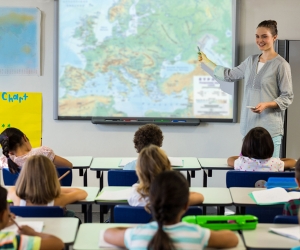
SELAS has the biggest series of geographical Wall Maps which cover all continents and countries worldwide in many languages and has been in the forefront of providing educational wall maps to schools. Our Wall Maps follow the Curriculum of Geography in Primary and Secondary Education of the Cyprus Ministry of Education and are very comprehensive, accurate and user-friendly.
They depict all hydrographic features, mountains, valleys, hypsometric/bathometric tints and settlements classified according to population. Most of our Wall Maps are recto verso and include a political map on one side and a physical map on the other side, or a physical or political map on one side and thematic maps on the other side.
Printed on high-quality paper including lamination, they are available framed or unframed, flat or packed in plastic tubes.
Our Wall Maps are ideal for schools, students and anybody else who is interested in studying the geography of a region in detail. They are also an aesthetic ornament for every office and company.
SELAS also produces Custom Wall Maps for many companies and organizations.
SELAS has extensive expertise in the design and production of 3D raised-relief maps and is the only company in Cyprus specialising in relief-printed cartography.
Combining advanced technology with cartographic expertise and creative design, we produce three-dimensional maps that offer a unique and highly engaging way of visualising geographical space.
Our raised-relief maps can be produced for virtually any area and can be customised according to the requirements of the project. Available formats include:
By transforming conventional two-dimensional mapping into a three-dimensional representation, raised-relief maps help students and viewers develop a clearer understanding of terrain, elevation, landscapes and spatial relationships.
They are particularly effective as educational displays and are also impressive visual pieces for institutions, offices, organisations and corporate environments.

SELAS has long expertise in the production of 3D Raised-Relief Maps and is the only Cypriot company that makes relief printed cartography.
We undertake the design and manufacturing of 3-Dimensional Maps, using state-of-the-art technology and our artistic talent.
We can undertake the production of a Raised-Relief Map of any area you request.
The 3-Dimensional Maps are very impressive with a completely different perspective. The maps can be either orthophoto reliefs, printed with aerial photographs (orthophotos), or just topographic relief maps.
Our Raised-Relief Maps are ideal for schools, students and anybody else who is interested in studying the geography of a region in detail. They are also an aesthetic ornament for every office and company.
Maps are powerful learning tools, but geography becomes even more engaging when students can explore, interpret and interact with geographical information.
Alongside our maps and atlases, SELAS develops learning activities and educational support materials for Geography and Cartography.
We provide teachers’ guides and supplementary educational resources for schools teaching in Greek, English and French, supporting educators in creating engaging and meaningful geography lessons.
Our team also has extensive experience in geography and cartography education and can provide:
Whether the need is a classroom map, a complete atlas, supplementary learning material or a customised educational project, our team of experienced geographers and cartographers can provide professional guidance and develop solutions that combine educational value with high cartographic standards.
At SELAS, education is supported by decades of experience in geography, cartography, mapping, publishing and research.
Our educational products are developed by a specialized team with expertise in geography and cartography, supported by our wider experience in digital mapping, research and publishing.
This multidisciplinary approach allows us to create educational resources that are:
Accurate
Based on sound geographical and cartographic knowledge.
Educational
Designed around the needs of students and teachers.
Engaging
Using clear visual communication, imagery, graphics and contemporary design.
Innovative
Combining traditional cartography with modern technologies and digital solutions.
Customisable
Developed to meet the specific requirements of schools, institutions and organisations.
SELAS works closely with schools, educators, educational institutions and public-sector organizations to provide high-quality geographical and educational resources.
Our long-standing collaboration with the Cyprus Ministry of Education, Sports and Youth, has enabled us to contribute to the development and production of educational mapping resources for Primary and Secondary Education.
We also work with organisations and institutions on custom mapping and educational projects, providing solutions tailored to their specific needs.
Our team can help you identify the right combination of maps, atlases, 3D mapping, learning materials and digital resources for your educational environment.
For more than 30 years, SELAS has combined geographical knowledge, cartographic expertise and educational innovation to create resources that help students see, understand and explore the world.
From the classroom wall to the pages of an atlas, and from traditional maps to three-dimensional and digital experiences, we believe that maps are not simply representations of the world. They are tools for understanding it.
 Apart from the geography-based educational material we produce, we also offer teachers’ guides with support materials for the teaching of Geography and Cartography to Greek, English and French schools. We also have long expertise in teaching geography and cartography and offer tutorials and lectures to academics and teachers.
Whatever the school’s mapping needs are, our geographers and cartographers can assist and propose innovative quality educational products and services which respond to the highest cartographic standards.
Newsletter
Subscribe to our newsletter