Cyprus Hiking Maps: Topographical Maps for Trails & Mountain Biking
Cyprus is one of the most diverse outdoor destinations in the Mediterranean, offering everything from coastal walks to high-altitude forest trails. Whether you’re exploring the rugged coastline of the Akamas Peninsula or hiking through the forests of the Troodos and Pafos Mountains, having a reliable hiking map is essential.
While mobile apps are useful, they often fail in remote areas. That’s why experienced hikers and mountain bikers still rely on detailed topographical maps for accurate navigation and safety.
Why You Need a Hiking Map in Cyprus
Many of Cyprus’ best trails are located in remote areas where mobile signal is weak or completely unavailable. Relying only on your phone can quickly become a problem.
A high-quality topographical map gives you:
- Accurate terrain and landscape details
- Clearly marked hiking and cycling routes
- Elevation and contour information
- Reliable offline navigation
- Better trip planning and route awareness
Even if you use apps, a paper map is the safest backup.
Best Regions for Hiking & Mountain Biking in Cyprus
Akamas Peninsula
The Akamas Peninsula is one of the wildest and most untouched regions of Cyprus, making it ideal for both hiking and mountain biking. It offers some of the most scenic coastal hiking trails on the island.
Popular routes include:
- Aphrodite Trail
- Adonis Trail
- Smigies Trail
- Pissouromoutti Trail
Maps are especially useful here due to:
- Limited signage in some areas
- Remote terrain
- Multiple intersecting trails
Troodos Mountains
The Troodos Mountains offer a completely different experience, with dense forests, rivers, and higher elevations.
You’ll find:
- Long-distance hiking routes
- Forest cycling paths
- Sections of the European E4 trail
A detailed map helps you:
- Navigate elevation changes
- Identify water sources and forest roads
- Plan longer, more complex routes
Pafos Forest & Other Regions
Beyond the well-known areas, Cyprus has many hidden gems across regions like Pafos Forest, Laona plateau, Machairas, Marathasa, Cavo Gkreko etc.
These areas combine:
- Nature trails
- Cultural landmarks
- Scenic viewpoints
Because trails are often shared between hikers and cyclists, having a clear map improves both safety and navigation.
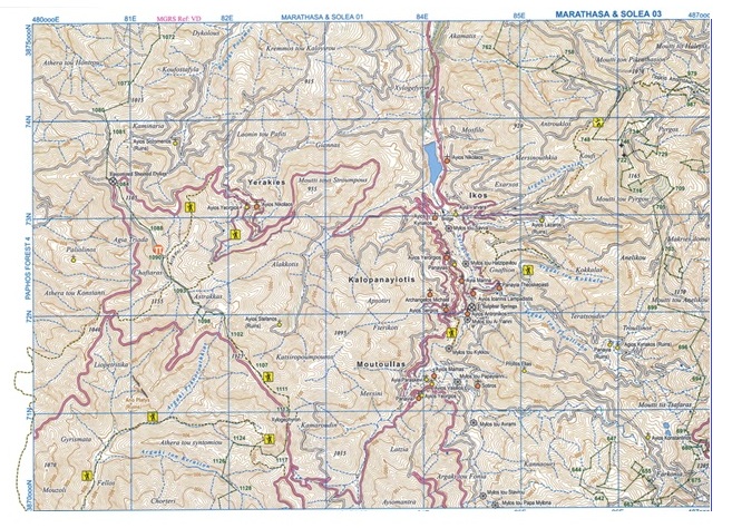
What Makes a Good Topographical Map?
Not all maps are made for hiking. A high-quality hiking map should include:
- Large Scale of 1:25,000 for detailed navigation
- Contour lines and elevation data
- Clearly marked trails and routes
- Forests, rivers, and natural features
- GPS compatibility (UTM / WGS84)
These features allow you to fully understand the terrain before and during your trip.
Official Topographical Maps of Cyprus
If you’re looking for complete coverage, the official map collection available here:
https://www.selas.com.cy/product/topographical-maps-and-natural-trails-of-cyprus/
It includes:
- 104 detailed maps at 1:25,000 scale
- Coverage of key regions like Troodos and Akamas
- European E4 trail routes
- Geological and terrain information
- Full island coverage divided into 12 regions
These maps are designed for both recreational users and professionals who need precise navigation tools.
Paper Maps vs GPS Apps
Digital navigation tools are convenient, but they come with limitations.
GPS Apps
Pros: Easy to use and real-time tracking
Cons: Signal issues in remote areas, battery dependency and limited terrain detail
Paper Maps
Pros: Always available (no signal needed), highly detailed terrain information and reliable in all conditions
Cons: Require basic navigation skills
The best approach is to use both together.
Tips for Using Hiking Maps in Cyprus
- Always carry a physical map
- Learn basic map reading (contours, scale, direction)
- Plan your route before starting
- Check elevation changes to avoid difficult terrain
- Combine your map with a GPS device for accuracy
Frequently Asked Questions
Do I really need a hiking map in Cyprus?
Yes. Many trails, especially in mountain and forest areas, have limited signal and signage.
Are GPS apps reliable in Cyprus?
Apps are useful, but not fully reliable in remote regions.
What is the best map scale for hiking?
A 1:25,000 scale is ideal for detailed navigation and route planning.
Can these maps be used for mountain biking?
Yes. Many trails in Cyprus are shared between hikers and mountain bikers, making topographical maps essential for both.
Explore Cyprus with Confidence
Whether you’re planning a short nature walk or a full-day mountain adventure, having the right map makes all the difference. It improves safety, helps you navigate with confidence, and allows you to fully experience the natural beauty of Cyprus.
Ready to explore?
View the full collection of official hiking maps here:
https://www.selas.com.cy/product/topographical-maps-and-natural-trails-of-cyprus/
