GIS Services
Leading Provider of Geographical Data to European and Global Markets

SELAS has implemented a large number of GIS projects for public and private sector organizations, covering a wide range of applications, including navigation, retail, distribution, telecommunications, mapping and local government.
With more than 33 years of experience in cartography and Geographic Information Systems (GIS), the SELAS team brings extensive knowledge and technical capabilities in the implementation of GIS projects and provides consultancy services to organizations seeking to make effective use of GIS technology.
Our GIS services include:
MapCyprus™ is a comprehensive digital geographical database of Cyprus, developed and continuously enriched through more than 33 years of experience in the collection, processing and management of geographical data.
The database provides large-scale, high-resolution GIS data for Cyprus, available in different projection systems and compatible with widely used GIS software. The data support a wide range of applications and can be provided to organizations in European and global markets, including navigation and location-based services.
The geographical data are developed and managed using state-of-the-art technologies, photogrammetric methods and other data collection and processing techniques. The data are continuously revised and subject to quality control procedures.
The database includes a navigable road network at scales ranging from 1:5,000 to 1:10,000, with information on road connectivity and attributes such as road category, street name, street numbering, direction and speed.
GIS data are continuously updated through technologically advanced processes and a variety of controlled sources. A dedicated software tool is used for the administration and management of the geographical data.
The navigable geographical database can be used in GPS and navigation applications and supports the development of interactive digital applications according to specific client requirements. Geographical data can also be provided through Map Services.
The extensive GIS expertise and experience gained through projects in Cyprus and abroad provide the capabilities required to support complex geospatial projects and applications.
MapCyprus™ Geographical data consists of:
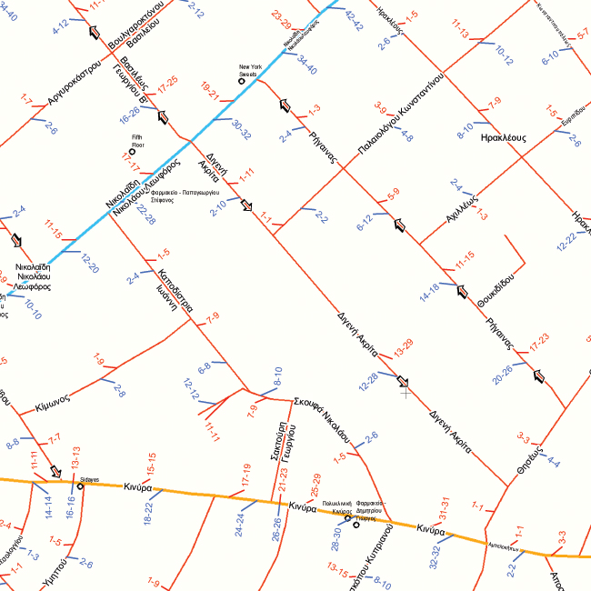

Rivers, Streams, Lakes, Salt Lakes.
MapCyprus™ includes an extensive database of Points of Interest (POIs) covering the whole of Cyprus. The POIs are structured into 21 main categories and 121 subcategories, providing detailed geographical information for a wide range of locations, businesses, services and facilities.
The database includes 11,370 Points of interest, covering categories such as:
Points of Interest provide valuable information for companies and organizations seeking to visualize and analyze geographical data to support decision-making. POI data can be used to study market trends, understand the competitive environment, identify potential development opportunities and support location-based analysis.
The data can be useful across a wide range of sectors, including retail, telecommunications, navigation and location-based services, municipalities, healthcare, tourism and other businesses and organizations.
A sample of the MapCyprus™ Points of Interest database is presented below.


Geo-processing services enable the processing and analysis of geographical data to produce specific results and support a wide range of business and operational requirements.
Geoprocessing services can provide answers and solutions to questions such as:
These requirements can be addressed through a range of geoprocessing services, including:
The above services are supported by software service modules available through the Internet, which can be used as building blocks for the development and integration of applications requiring these types of geospatial functionality.
The service modules can be combined and adapted according to the requirements of each application, enabling the integration of geoprocessing and spatial analysis functionality into existing or new systems.

The service enables users to locate addresses and points of interest (POIs) on the map. The search engine uses a Free Text Algorithm, allowing users to enter addresses or POIs in a flexible text format.
The search can include, for example, a free-text query such as “banks in Nicosia”, a partial search such as “hotel”, an incomplete address such as “Makariou 5 Street”, as well as searches containing spelling errors or latin characters.
This flexible search functionality facilitates the identification of addresses and points of interest even when the information provided is incomplete or does not follow a standardized format.
The routing service calculates routes between two or more locations and allows users to select the means of transportation, such as car, public transportation or walking.
The service can calculate the most appropriate route based on different criteria, including shortest distance or shortest travel time. It also supports additional routing parameters, such as defining intermediate stops and specifying whether the route should be optimized for pedestrian or vehicle travel.
These capabilities allow routing functionality to be adapted to the specific requirements of different applications and use cases.

This geoprocessing service calculates the geographical area that can be reached from a starting point within a predetermined travel time, such as a 8-minute drive. The resulting service or coverage area can be displayed on the map as a polygon.
For example, an 8-minute service area includes the streets that can be reached within a travel time of eight minutes or less from a specified starting point. This functionality is useful for businesses and organizations that need to define and analyze the areas served by their facilities, such as delivery restaurants and supermarkets. It can also support the analysis of the potential customer base within a defined travel-time area around each location.
The results of geoprocessing services do not necessarily have to be displayed on a map. Depending on the requirements of the application, the output can also be provided as numerical or textual information. For example, the service can identify the number or locations of customers within a 10-minute travel time from a store, or calculate the distance and estimated travel time required to reach a specific area.

Demographic data associated with the calculated polygon can also be provided, including information such as the percentage of the population covered and age distribution.
This service enables the optimization of fleet routes by calculating delivery plans based on criteria such as minimum travel time or minimum distance. It can be used to organize the delivery of orders from a company’s premises to its customers, taking into account the available vehicles and drivers.
Optimizing fleet routes helps companies reduce travel time and operating costs while increasing the productivity and efficiency of their distribution operations.
The Closest Facility service identifies the nearest facility to a specific location or event and calculates the distance and travel time between them.
For example, in the event of a fire, the service can identify the nearest fire station, calculate the distance and estimated travel time to the incident location, and provide the appropriate route for reaching the site.
The Location Allocation service identifies suitable locations for facilities that provide goods or services and determines how these facilities can best serve a defined set of demand points.
The service can be used to determine the number and location of facilities required to serve specific demand points as efficiently as possible, taking into account factors such as geographical coverage, travel distance and accessibility.
For example, the service can be used to determine the optimal distribution of stores or supply facilities so that they can serve the largest possible geographic area within the shortest possible travel time.
The live Information Services enable dynamic information to be displayed on a map, such as pharmacies on duty, current prices of products or services, cultural events, and other events or information that change over time or are available for a specific period.
Applications can display live information on the detailed and continuously maintained cartographic background of Cyprus provided through MapCyprus™, offering a reliable geographical foundation for digital applications and location-based services.
Geoprocessing services can serve as building blocks for the development and integration of applications, providing ready-to-use functionality that can be adapted to the specific requirements of each project.
The geoprocessing services described above are available through APIs and can be provided in the following ways:
Geographical data, GIS software, consultancy and training can also be provided to support organizations in the development and implementation of their own geoprocessing services and applications.
The use of geoprocessing services provides companies and organizations with a range of benefits, including:
Extensive experience in the implementation of GIS projects enables the development of business solutions for geographical data visualization, spatial analysis and decision-making, tailored to the specific requirements of each organization.
Customized WebGIS and interactive web maps can combine geographical and business data to provide a clear visual representation of business activity. For example, a web map can display:
These solutions can be tailored to the specific needs of organizations across a wide range of sectors, including retail, logistics, real estate and other businesses requiring geographical visualization and spatial analysis.
Postal code Maps
Postal Code Maps are a useful tool for businesses and organizations for visualizing and analyzing geographical data, planning delivery routes, managing distribution fleets, distributing goods and services, organizing the distribution of promotional material, visualizing demographic data, conducting statistical analysis and supporting other location-based business needs.
Postal Code Maps can be prepared for any geographical area, from individual areas and cities to districts or the entire country. They can be produced in different scales, sizes and formats, including printed and digital maps.
Depending on the requirements of each organization, postal code maps can include:
The maps can therefore be customized to meet the specific requirements of each business or organization, supporting spatial analysis, business planning and decision-making.

With extensive experience in GIS projects and a team of qualified professionals, independent GIS consultancy services can be provided to organizations seeking to make effective use of GIS technology and geographical information.
Consultancy services include the following areas:
GIS Project Management:
GIS projects are managed following recognized PMI (Project Management Institute) standards and techniques. The project team evaluates the factors that can affect successful implementation, including the clarity of project objectives and deliverables, team composition, stakeholders and their roles, project risks and realistic scheduling. Project progress and the achievement of the defined objectives are continuously monitored and evaluated.
Geospatial Database Design:
Geospatial database design is a core component of a GIS system and has a direct impact on its efficiency, speed and performance. Appropriate database design enables the effective organization and management of geographical data and supports its integration with business and other information systems.
GIS databases can be integrated with corporate Business Intelligence (BI) databases, enabling geographical and business information to be combined and analyzed to support informed decision-making. Depending on the requirements of each organization, GIS databases can be provided through Web Map Services (WMS) or in Esri-compatible open data formats.
Software & Hardware Integration:
ArcGIS can be used as a GIS platform across desktop, web and mobile environments. Its architecture and interoperability with a wide range of hardware and technology environments make it suitable for GIS implementations across different industries and organizational requirements. The existing software and hardware infrastructure of an organization can be assessed to determine the most appropriate approach for integrating GIS with its existing systems and technologies.
Maintenance & Support:
Maintenance and support services can include training and technical support programs, help-desk services, software and hardware upgrades, system configuration and the implementation of system extensions to meet changing organizational requirements.
Newsletter
Subscribe to our newsletter